Index of All Cemeteries Alphabetical Index of All Burials Previous Page
Use the following to search across all the cemeteries listed.
Example: "Smith, Roger" (yes, use the quotes)
070 DUNNAGAN CEMETERY
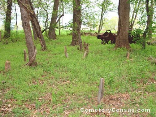
Location - Off Chilton Rd near Eldora Rd, Ararat, Surry Co., NC.
Coordinates: 36d 23m 14.9s N; 80d 33m 59.1s W Click here for Online Maps
Directions: From intersection of US Hwy 52 and NC Hwy 268 in Pilot Mtn, go west on NC Hwy 268 for 6.4 miles, then turn right on Eldora Rd and go north for 3.5 miles, then turn right on Chilton Rd and go less than .1 mile on Chilton Rd. Cemetery is in the woods to the right just past a red barn.
Surveyed by Andy Hennis on May 6, 2006.
Township or district: Eldora.
Public or Private: Private property.
GPS Accuracy (ft.): 14.
Elevation above sea level (ft.): 1095.
Status of cemetery: Abandoned.
Surry County Parcel Number: 5946-00-14-3225.
There are no legible stones and the name of this cemetery could not be confirmed.
Web page updated 15 April 2021
Index of All Cemeteries Alphabetical Index of All Burials Previous Page
|
|
 |