Index of All Cemeteries Alphabetical Index of All Burials Previous Page
Use the following to search across all the cemeteries listed.
Example: "Smith, Roger" (yes, use the quotes)
324 UNKNOWN CEMETERY
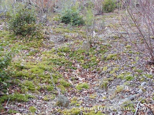
Location - Off Tom's Creek Rd, Pilot Mtn., Surry Co., NC.
Coordinates: 36d 23m 26.0s N; 80d 32m 07.0s W Click here for Online Maps
Directions: From intersection of US Hwy 52 and NC Hwy 268 in Pilot Mtn, go west on NC Hwy 268 for about 2 miles and turn right on Tom's Creek Rd. Then go another 1.3 miles and the cemetery will be on the left at the beginning of a stand of trees just after you pass Sam Fulk Rd. Graves can't be seen from the road, but are only a few feet into the woods and is surrounded by a black vinyl rope.
View #2 of the cemetery. View #3 of the cemetery.
Surveyed by Bob Carter and Andy Hennis on March 24, 2007.
Township or district: Long Hill.
Public or Private: Private property.
GPS Accuracy (ft.): 10.
Elevation above sea level (ft.): 965.
Status of cemetery: Abandoned.
Surry County Parcel Number: 5946-00-85-5467.
Cemetery has no marked graves. There are about 12 graves and all are small field stones..
Web page updated 15 April 2021
Index of All Cemeteries Alphabetical Index of All Burials Previous Page
|
|
 |